Ice Climbing in the Kiruna
area,
Lapland, Northern Sweden
|
During northern Sweden's long winter there is a keen
group of climbers in K3 (Kiruna klätterklubb - Kiruna Climbing
Club) who devote themselves to ice climbing in the
parts of Sweden and Norway that are within reach of Kiruna,
Lapland.
The main areas are:
|
|
* short routes (up to 3 pitches long) beside the E10
highway between Torneträsk (50 km west of Kiruna) and
Narvik and Bjerkvik (in Norway).
* longer routes (up to 7 pitches) at Stora Sjöfallet
(south of Gällivare/Malmberget), and in Spansdalen,
Lavangen (an hour north of Narvik in Norway).
For a more up-to-date guide in pdf-format, click here (9 MB pdf-file), updated 2014-03-15.
|

|
|
WEST OF
KIRUNA
TORNETRÄSK:
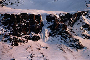
The station of Torneträsk lies 50 kilometres west of
Kiruna beside the E10 highway, where the road meets the lake
of the same name. There is a frozen waterfall, Falska blondiner (Peroxide blondes) which
forms in the early winter a couple of kilometres past the
turn-off to the station, below a radio mast. This
provides a 120-metre route with a short steep start, a long
easy-angled middle section, and about 30 metres of 75 degree
ice at the top. Later in the winter the climb is
usually out of condition, as much of the lower part of the
waterfall is buried in snow, and a large cornice forms at
the top. The usual descent is to the left from the top
of the climb.
Approach: c. 45 mins. Descent about the same.
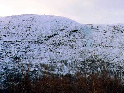
The Torneträsk waterfall is on the right, just left
of the mast on the skyline (photo: Rick McGregor)
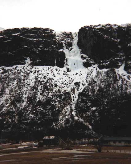
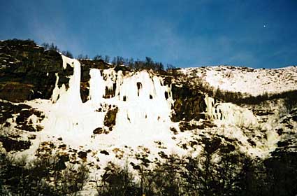
KAISEPAKTE:
70 kilometres from Kiruna above the E10 highway is the
formidable cliff line of Kaisepakte, overlooking the large
lake of Torneträsk. The best approach is straight up
from below the main waterfall following a slight ridge which
avoids the sometimes avalanche-prone snow-slopes on either
side. The approach takes 60-90 minutes. Ice conditions on
Kaisepakte are often difficult, especially in the middle of
winter (probably because the fall is north-facing and never
gets any sun), but are often better in the spring when the
temperatures begin to increase.
* A broad waterfall forms in the middle of the cliff
early in the winter, and stays there until late in the
spring. It provides two pitches of steep ice climbing,
with some vertical sections. There is an enjoyable route
which follows the lefthand edge of the waterfall. To
descend, either abseil or traverse right along the edge of
the escarpment until it is possible to descend towards the
old station building.
* A couple of hundred metres to the right of the main
waterfall is another broad waterfall which starts a short
distance up a prominent gully. It provides about 55 metres
of 80-90 degree ice up to where the angle eases. Descend by
abseil, or continue more easily (?) to the top. First recorded ascent: Rick McGregor and Anders Hedefalk, 26 November
2000.
* Near the righthand end of the escarpment is a smaller
waterfall (above the railway station). This provides a steep
pitch of ice climbing and a pitch of rock to finish. First
ascent: Peter Öhman and Kevin Edwards, c. 2000. Descend
to the right.
* At the far righthand end of the escarpment, about 60-90 mins walk from the railway station, is a new area with about 8 routes (50-90m): The Hidden Valley (Gömda dalen). Photos
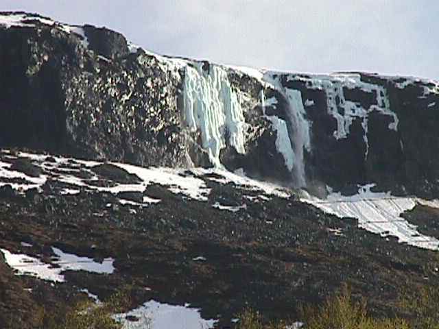
Photo: Kaisepakte in mid-June
LILLPAKTE:
Lillpakte is the local climbers' unofficial name for the
smaller cliff above the E10 some 5 kilometres beyond
Kaisepakte. It is so named because it looks like a
miniature version of the latter feature. From a
parking area beside the road the approach up through birch
forest and block terrain (best avoided by going up either
left or right of the waterfall) takes about an hour.
The waterfall is clearly visible from below, dividing into
two main columns, with a roof draped with icicles
between. The right hand column provides about 25
metres of steep climbing, and then, if one chooses to climb
off the top, a pitch of snow climbing. The left hand
column is longer, and can be done in one long pitch, or two
shorter ones. The descent is by abseil or to the left
from the top (take care in avalanche conditions).
STORDALEN:
There are long, low-angled ice slopes and steeper,
shorter routes at Stordalen, about 80 km west of Kiruna or
10 km east of Abisko. The steeper routes are at the
righthand end of a 25 m high cliff-line, and do not always
form.
ABISKO:
Abisko is a tourist resort 100 km (about an hour) west of
Kiruna beside the E10 highway which leads to Narvik in
Norway.
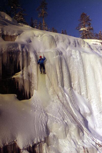
Rihtanjira is the steep stream that descends to
the left of the chairlift just west of Abisko Turist. Early
in the winter it makes for a long alpine climb with a short
steep pitch early on and a longer one at the top. There are
other short steps which can often be avoided. Later in the
season this stream becomes very avalanche-prone, so use your
discretion. Approach: drive or walk to the lift station and
then contour to the left across to the stream. Descent:
follow the chairlift down, with a detour to the west to
avoid a cliff that the chairlift goes over near the top.

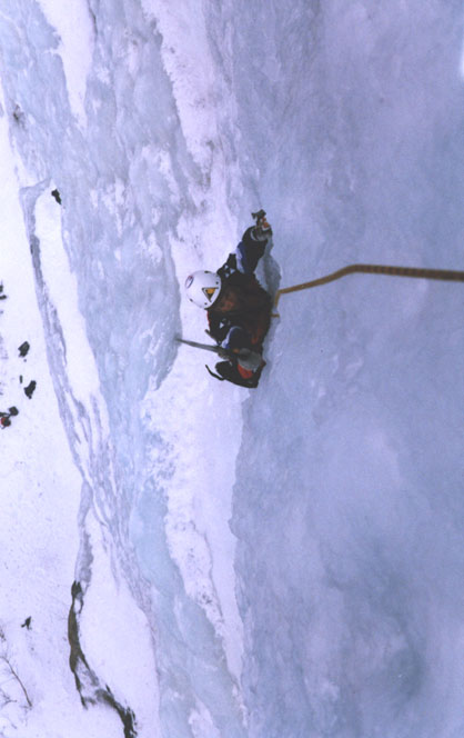
Approaching the top section of Rihtanjira (photo: Rick
McGregor)
|
|
|
Left: Abiskojokken (climber: Peter Öhman, photo:
Rick McGregor)
There are two areas near Abisko which provide a number of
short training climbs:
• In the Abisko canyon below the bridge (Jokken),
and
• on a roadside cutting a couple of kilometres towards
Björkliden (Kurvan).
|
|
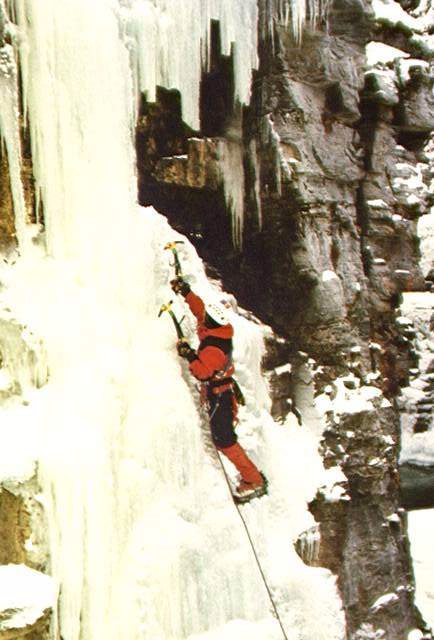
Abisko Canyon (Abiskojokken):
To find the ice climbing in the canyon, drive to the
bridge over the Abisko stream (outside Abisko
Turiststation). A fixed rope leads down to the stream,
a short distance to the true right (looking downstream) of
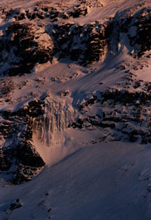
the bridge.
* The first waterfall which freezes at the
start of the winter is between the fixed rope and the
stream, and gives a 15 metre climb on 70 degree ice (picture
on left). A mixed route just left of this waterfall
has also been top roped.
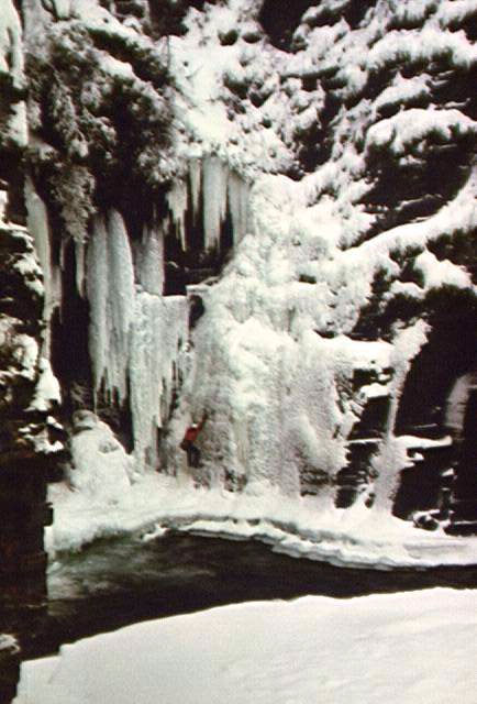
* Later in the winter (towards Christmas)
it is possible to cross the stream on a shelf of ice below
the tunnel that the stream flows through. A broad
waterfall 20 metres left of the stream gives a 15 metre
climb, steep at the bottom, lower angled near the top (a
final snow slope leads up to a large leaning tree which
provides the anchor) (picture on right). It is also
possible (usually done on a top rope!), to climb the left
hand side of the waterfall, and pull out from behind a
curtain of icicles onto an 85 or 90 degree headwall at the
top left of the waterfall.
* Later still, a slim vertical pillar
forms between the stream and the broad waterfall, and gives
a good 10 metre climb which can be led in the right
conditions.
Right: Abiskojokken (climber: Peter Öhman, photo:
Rick McGregor)
|
|
|

"Kurvan"/The Bend, Abisko, with Lapporten in the
background (climber: Tomas Mikusi)
|
"Kurvan" (The Bend/The Road Cutting):
Drive a couple of kilometres past Abisko Tourist Station towards
Björkliden. The road cuts through a point just after a section
of road which is marked off as an area of avalanche danger. On the
left, right beside the road, are a number of 80-90 degree ice columns
on a hundred metre long and up to10 metre high cliff. For a guide (in
Swedish) to the bolted mixed climbs on this wall see Kurvan
Parking is a bit of a problem. The safest option is to continue to
a side road 400 metres further towards Björkliden.
NJULLA/NUOLJA:
There are two main waterfalls on Njulla, on the cliffline up the
hillside above and north of Kurvan (just north of Abisko). The
routes are about 30 metres long, and generally not too steep.
Take extreme care with the approach, as the slope is very avalanche
prone (there has been a fatality here). The usual approach is from
the western end of the Njulla railway tunnel.

Njulla, Abisko
LOKTA:
There are a number of excellent one- and two-pitch waterfalls on
the steep mountainside of Loktatcohkka, above the old railway
station Björkstugan, about 15 km west of Björkliden.
|
|
Lokta (photos: Peter Engström)
"The Big Blue" on the left, with an easier grey waterfall
at the far left of the picture. Descend by abseil or walk
down the gully to the left.
The lefthand picture below shows a broad waterfall above
where the road is closest in under the mountainside. The
snowfield above it leads up to another, steep,
waterfall.
The righthand picture below shows the waterfall furthest
right of those in this area. Descend by abseil or climb up
and left and then descend a gully (which can be
avalanche-prone).
|
|
|
|
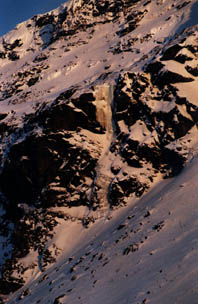
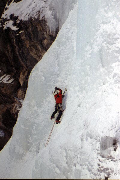
Oktoberfest
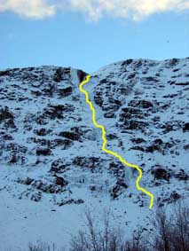
Oktoberfest with the route marked (photo: Dick
Johansson).
Click on the picture for a larger version.
Oktoberfest (ca 8 pitches) is a long route which climbs the
centre of the lefthand half of the mountainside, with 2 pitches
followed by lower-angled slopes for ca 100m, then 4 more steeper
pitches to finish. First ascent (?): Calle-Peter Engström, Lasse
Jakobsson, Dick Johansson and Rick McGregor, 26 October 2003. This
ascent did not climb the steep final pillar.
The approach took 30 mins and the descent (to the right at the top
then down the gully to the left of The Big Blue) about an hour.
Warning: this route and others on this part of the mountain are
probably dangerously avalanche-prone later in the season. Early
winter is probably the safest time for them, despite the thinner ice.
NORTHERN NORWAY
KALIX WALL:
The Kalix Wall (Kalixväggen) is the local name for an area a
few kilometres east of the T-junction where the E10 highway meets the
E6 halfway between Narvik and Bjerkvik (Narvik climbers call it Kvitbergan/The White Cliff). The routes are right beside
the road, and the area is easily recognised by a high cliff of
light-coloured rock, usually with a large icicle hanging down towards
a broad ledge at half height. There are two other routes further left
which provide some 25 metres each of climbing, one up through the
forest, the other in an obvious gully. Abseil from trees.

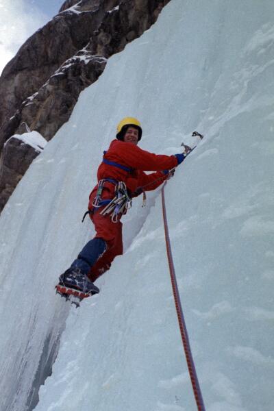
Anders Hedefalk topropes the icicle on Kalix Wall (photo: Rick
McGregor)
TRAELDAL/ELVEKROKDALEN:
About a kilometre north of the T-junction where the E10 meets the
E6 is a small road that leads up into a hidden valley (Elvekrokdalen)
above the signposted power station of Traeldal. Park halfway between
the turn-off and the T-junction at a gravel pit, and walk up the
forest road and continue up the valley for about half an hour. The
first waterfall one encounters wends its way down a gully ca 200 m
left of the main waterfall and provides a few pitches of varied ice
climbing (abseil back down off trees).
* The main waterfall is 60 metres high and nearly as many broad,
and provides two pitches of 70 to 80 degree ice. To descend, follow
the cliff-top down to the left until it is possible to make a
50-metre abseil back to the base of the cliff.
Pontus C:son Brandt on the main waterfall at Elvekrokdalen, Norway
(photo: Rick McGregor)
BJERKVIK:
A couple of kilometres west of Bjerkvik (on the road towards
Harstad) is a long series of road cuttings that provide numerous ice
and mixed routes up to 20 metres high.
SPANSDALEN:
Spansdalen is the valley which runs down from Fossbakken (on the
E6 highway 50 km north of Bjerkvik) to the Lavangen
fjord at Tennevoll. Fossbakken is about 200 km from Kiruna (about 3
hours' drive - the roads are slower in Norway, especially in the
winter). The valley is an ice climbing paradise, with numerous
frozen waterfalls on both sides. They range in length from one
to seven pitches long, and many of them have short approaches from
the road.
* One of the longest waterfalls is
Henrikkefossen, the impressive fall on the true left near the
bottom of the valley. It begins with a broad wall of 80 degree
ice which leads up for about 60 meters to a snow field. From
the top of the snow field, a section of 60 degree ice leads up over
bulges and past a short section of vertical ice to where the
waterfall narrows between an overhanging wall on the right, and a
steep slab (with potential mixed routes) on the left. In the
upper gully a short wall of 85-90 degree ice leads up to where the
fall widens again to offer a choice of exits - a steep ice pillar on
the right, a narrow snow gully straight up, and steep snow and ice to
the left (80-85 degrees). (Total: c. 7 pitches)
The easiest descent is to head right (towards the fjord) from the
top, until it is possible to climb down through steep birch forest
back to a gravel road which runs parallel to the river on the other
side from the main road.
* On the right of Henrikkafossen is the
very steep Søylefossen, first climbed by a Norwegian
party in March 1992 (and reported in the Narvik newspaper
Fremover in May 1993).
Hendrikkafossen, Spansdalen (photo: Rick McGregor)
* Also on the true left, further up the
valley, is a fine 4-pitch route which looks like a smaller version of
Henrikkafossen. It too starts with a broad wall at the bottom,
which steepens towards the top. After a snow field, a section
of vertical ice leads up to a groove against the cliff on the
right. Above, a series of bulges lead to the top.
It is possible to descend down a long snow gully some distance to the
left (away from the fjord), but the gully should be avoided in
avalanche conditions. Where the gully turns right, either
traverse out right c. 100 metres and do one 50 metre abseil from a
flat ledge, or traverse left and continue diagonally down through the
forest.
|
* Further up the valley, still on the
true left, are two more 4-pitch routes, a couple of hundred
metres apart. The right hand one starts with a broad
steep wall.
* The left hand of the two also has a
broad bottom wall, which can be avoided by climbing a 70-80
degree right-leaning ramp from the left. After a short
snow field, 75-80 degree ice continues past some ledges and
bulges to a lower-angled section below the steep final gully
which provides 80-85 degree ice and a fine finish.
From the top, walk left and then down to the steep snow
gully to descend (but avoid the gully in avalanche
conditions). Where the gully turns right, either
traverse out right c. 100 metres and do one 50 metre abseil
from a flat ledge, or traverse left and continue diagonally
down through the forest.
|
|
Right: Spansdalen, Norway (climber: Peter Öhman,
photo: Rick McGregor)
* There are a number of one- to
two-pitch routes halfway down the valley on the true
right. Park just after the road flattens out after a
steep descent. One gully offers a couple of different
waterfalls at its head: a broad 60 metre fall on the left;
and on the right a narrower 80 metre fall with a steep first
pitch which just reaches a horizontal belay tree on the
right, then continues up a series of steps to the top.
Abseil off trees to get back down from both routes.
|
|
|
|
Left: Spansdalen, Norway (climber: Rick McGregor)
* Back up the road 200 metres is an
excellent two-pitch route in a relatively confined
gully. There is a well sheltered belay site under an
overhang on the left after 45 metres. The second pitch
starts with a section of 80 degree ice, before easing off at
the top. Move out right to belay on trees (a fairly
full 50 metres). One 25 metre and one 50 metre abseil
lead back down on the right.
* Down the road 300 metres is a broad
waterfall of about 30 metres which goes up over a series of
steps to trees at the top.
* There are several short routes and a
longer low-angle route on the other side of the stream from
these routes.
|
SOUTH OF KIRUNA
HARSPRÅNGET/PORJUS:
Harsprånget (climber: Peter Engström, photo: Rick
McGregor)
Harsprånget is a dam on the Lule River between
Gällivare and Jokkmokk about 200 km (2 hours) south of Kiruna
and just south of the township of Porjus. Two short but wide
frozen waterfalls form in the gorge about a kilometres downstream of
the dam, one on each side of the river. They each provide less
than 10 metres of steep climbing (80-85 degrees), followed by a
longer low angle section.
For some information (in Swedish),
see the Gällivare Climbing Club's ice climbing guide (2004): http://klatterklubben.files.wordpress.com/2011/04/storasjc3b6fallet2.pdf
STORA SJÖFALLET:
The Suorva Dam area at Stora Sjöfallet provides 1-pitch
routes with easy access (photo: Rick McGregor)
Stora Sjöfallet is some 3 hours' drive south of Kiruna, near
the head of the Lule River. There are numerous long ice routes,
mostly on the northern side of the valley, between Suorva Dam and the
Swedish Tourist Association's hut Vakkotavarestugan.
For a translation of a guide published in the Swedish Climbing
Association's magazine Bergsport,with additional notes from the Gällivare Climbing Club's guide in Swedish (http://klatterklubben.files.wordpress.com/2011/04/storasjc3b6fallet2.pdf),
see: Stora
Sjöfallet

Greven and Grevinnan [The Count and The Countess], Stora
Sjöfallet (photo: Rick McGregor)
Scandinavian ice climbing links:
http://isklatring.no (Ice climbing areas in Norway with links to web-based guides)
Kiruna
klätterklubb (Kiruna Climbing Club)
Rick McGregor (rmcgregor*hotmail.com), updated 2014-03-16
